SIX/1 ClimatologyTHE BASICS: When we talk about climate we usually mean the general long-time conditions of temperature and moisture of an area, as opposed to weather which is more about clouds, winds and similar shorter-term conditions. In a sense, all worlds have climate regions and the difference between these regions is what we are interested in. Airless worlds, however, have a climate which is solely based upon energy infall (and perhaps hot spots) unmoderated by atmosphere, while hothouse worlds have very similar climate all over the surface. Climate is usually generated by energy infall from the local primary. As the energy (sunlight) reaches the surface of a world it heats it. In chapter FOUR we calculated the "typical" surface temperature, but the typical surface temperature isn't that useful for a specific region as the temperature varies over the surface. The temperature difference depends primarily on the angle the sunlight hits the ground with. At the areas near the poles (in a case of low axial tilt) there is less light per surface unit, and thus these areas are colder than the areas near the equator. The heated surface in turn radiates energy, to provide an energy balance. The greenhouse effect "traps" some of this outgoing energy, and raises temperatures. THE STRUCTURE OF THE ATMOSPHERE: The atmosphere of a planet can typically be divided into, from surface and upward, a troposphere, a stratosphere and a mesosphere. Beyond the mesosphere the atmosphere is so thin that gas can escape and particles get ionized. FOUR/3 described how the pressure falls with altitude.
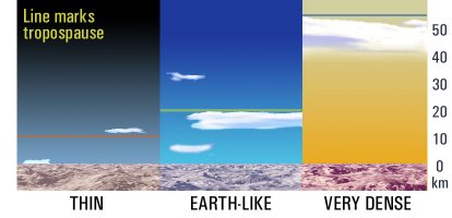
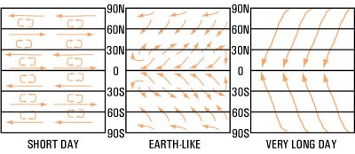
The troposphere is the lowest part, where the convection (rise and fall of matter, in this case gas, of various temperatures) take place. The troposphere usually gets colder the farther up one gets, and most clouds tend to form in the troposphere. In some cases the troposphere temporarily disappear due to lack of convection. This is most common on thin atmospheres in nighttime situations. The troposphere otherwise typically extend up to 10-30km. The border between the troposphere and the stratosphere is called tropospause (see figure above). Beyond the troposphere lies the stratosphere. Here is very little convection, and temperatures stop dropping. Sometimes they rise gradually towards the mesosphere. The stratosphere is typically rather clear, but clouds can form here too. On Earth, these clouds are made of ice crystals, on Mars of carbon dioxide. The stratosphere is also the place where the ozone layer is most likely to be found on worlds with free oxygen, though in very thin atmospheres it may be in the troposphere. Above the stratosphere is the mesosphere. Here, temperatures rise again but the air is very thin and thus the heating effect is very small. Cloud formation in this area is rare, but night glowing (noctilucent, see TEN/2) clouds from meteoric dust and aerosols of smog are a possibility. THE BIG PATTERN AND THE CORIOLIS FORCE: The basic pattern generated on a world with non-extreme axial tilt is that the air is heated in the equatorial area and cools off near the poles. Thus, the pattern would be north-south, with cooler surface winds moving towards the equator. On worlds that rotate fairly fast, this is made complex by the coriolis force. Due to the rotation, the winds will be deflected, to the right in the northern hemisphere and to the left in the southern hemisphere. The force is stronger towards the poles and zero at the equator, and stronger the higher the velocity of the winds are. The coriolis force can be calculated from CF = 2 x A x W x sin(L)
We understand that the rotation of the world is very important, a world that rotates half as fast as Earth has only half possible coriolis force. On a world with high wind speeds and fast rotation, like many gas giants, the coriolis force will be so strong as to form bands of east-west winds and no polar-equatorial winds. On worlds with a large axial tilt the coriolis force still works, but one has to consider that the area which receives the most solar infall seldom is at the equator but closer to the poles. The basic pattern of surface winds is very important to climate, as it not only moves cool air from poles and hot air from low latitudes, but also moves moisture from oceans.
On the truly slow rotating (slower than the "Very Long Day" above, worlds the pattern will also be influenced by the large temperature difference between night and day as opposed to not as prominent poles/equator difference. Cool air from the nightside will flow over the surface to the day-side, and heated air will be transported back to the night-side higher up in the troposphere. (In the same way, the "Very Long Day" example above has motion towards the poles in the upper troposphere). The big pattern is also influenced by land masses, which are heated faster than oceans. This is very apparent on a world like Earth with large continents in one hemisphere. More on continental high pressure zones and ocean low-pressure zones in SIX/3. Note that the figure above relates to surface winds, the winds in the upper parts of the atmosphere are another matter. TEMPERATURE DIFFERENCES/LATITUDE: As already mentioned, temperatures drop with lower angles of solar infall (for worlds with low axial tilt this is in the high latitudes). The hottest areas of a world are those with longest amount of sunlight coming in from straight overhead. This mean that the potentially hottest areas of a world are at the tropics, not the equator, as the sun is longer in zenith consecutively at the tropics than the equator. (Of course, for worlds with very low axial tilt this does not matter much). TEMPERATURE DIFFERENCES/ALTITUDE: The higher up one goes the thinner the atmosphere gets, and the temperature drops. How fast the temperature drops depends on how much moisture the atmosphere holds and the structure of the atmosphere. For Earth-like atmospheres, temperatures can drop about 6 degrees per kilometer in the troposphere. Cooler atmospheres lose temperature slower, as would denser ones. TEMPERATURE DIFFERENCES/DIURNAL: Naturally, temperatures vary over the local day too. This has little effect on strict climate, but will affect weather. The longer the rotating period is the hotter the day will be and the cooler the night will be. When the days are long enough (a planet rotating slowly) the diurnal difference may be the distinct one, like our seasons. SEASONAL DIFFERENCES: This depends on how clear-cut seasons a world has, of course. There are two main reasons for seasonal variations, axial tilt and eccentricity. (A third reason can be the radiation from a binary star in eccentric orbit.) Axial tilt is rather simple, the more axial tilt the more distinct seasons the world will have. A side-effect is that low axial tilt tend to stabilize climate zones and extend the equatorial and polar ones (larger deserts and ice caps, for instance). Axial tilt has by far the most effect the closer to the poles one get. Eccentricity, on the other hand, affects the entire planet and unlike axial tilt the entire world gets cooler or hotter, so moderation is less effective. In extreme-eccentricity cases, the atmosphere may undergo significant changes over a year, if for instance water vapor reinforce greenhouse effect at closest separation while frozen oceans increase albedo on furthest separation. These effects can both moderate and amplify temperatures. (Water vapor also increase cloudiness which increase albedo, for instance.) MODERATION BY ATMOSPHERE: The atmosphere moderates temperatures as it stores heat. It also increase albedo by cloudiness and the circulation of the air redistribute hot and cold air systems. Worlds with fairly thick atmospheres and distinct greenhouse effects have smaller differences between day and night, but also between seasons and latitudes. Cloudiness can vary over the surface, and areas with few clouds have more temperature difference (deserts tend to fall in this category). If the atmosphere is dense enough, it will effectively counter almost all differences, axial tilt, rotation-based and latitudes. However, such worlds are also likely to have runway greenhouse effects. MODERATION BY OCEANS: Oceans are very effective for heat storage, and the currents also moderate latitude differences. Thus, worlds with large oceans (and locations near such oceans) will have less temperature differences. Currents can modify global climate extensively. On Earth, the difference between polar and equatorial climate would be 10-15 degrees higher if the oceans and air masses didn't moderate. (A world with fast rotation and little oceans thus would have more extreme polar and equatorial climates.) Oceans also serve to produce clouds, which in themselves moderate climate. Local climate is also strongly affected by oceans ... the further from an ocean one gets the larger the amplitude in temperature gets, especially on a seasonal basis. MODERATION BY AXIAL TILT: If a world undergo seasonal change due to axial tilt, this will moderate temperatures. Worlds with low axial tilt have, in general, larger temperature differences than those with a significant tilt. MODERATION BY SURFACE: While the solid surface is less good than oceans as heat storage, it still can store heat and the difference in surface structure is also important for local climate. Vegetation in particular moderate climate, the denser the better, by absorbing energy and slowly radiating excess heat and water vapor. On the other hand, ice caps serve to decrease the temperature by cooling the air, so they amplify temperature differences instead of moderating them. CALCULATING SURFACE TEMPERATURES: This is an issue of severe complexity as there are so many factors to consider. I strongly suggest using these as a guideline only, not as some way of calculating exactly how cold or warm a specific place is. And to remember that there always are differences from day to day and over longer periods. The first step is to calculate the temperature for different latitudes. For simplicity, we use ten ranges of latitudes: |
| Range | 1 | 2 | 3 | 4 | 5 | 6 | 7 | 8 | 9 | 10 |
| Latitude | 0-5 | 5-15 | 15-25 | 25-35 | 35-45 | 45-55 | 55-65 | 65-75 | 75-85 | 85-90 |
| Modification (Low) | 1.10 | 1.07 | 1.5 | 1.03 | 1.00 | 0.97 | 0.93 | 0.87 | 0.78 | 0.68 |
| Modification (Average) | 1.05 | 1.04 | 1.03 | 1.02 | 1.00 | 0.98 | 0.95 | 0.90 | 0.82 | 0.75 |
| Modification (High) | 1.02 | 1.02 | 1.02 | 1.01 | 1.00 | 0.99 | 0.98 | 0.95 | 0.91 | 0.87 |
The three different modifications signify different planetary moderation potential. The Low Mod is intended for worlds with very little moderation (no oceans, fast rotation giving east-west weather patterns, low axial tilt, thin atmospheres), the Average Mod for worlds roughly Earth-like (part ocean, average rotation, average axial tilt, normal atmosphere) and the High Mod for worlds with large moderation (ocean worlds, dense atmospheres, slow rotation giving north-south weather patterns). Worlds with dense enough atmospheres (like Venus) would not moderate temperatures at all, just use 1.0 all over. Of course, you may want to extrapolate modifications for a world that is slightly less moderated than Earth, or perhaps which has very different hemispheres like one land and one ocean. For every latitude use the surface temperature (in Kelvin) from 4.5.2 and multiply with the modification. Subtract 273 to get the temperature in Celsius. This is the base temperature for the latitude. For a specific location in the latitude, temperatures may be higher or lower, though. Ocean currents can raise or lower temperatures by up to ten degrees or even more in polar locations. Ice caps can cause a drop in temperatures of ten degrees as well, and highlands will be cooler due to elevation. The next step is to find the seasonal effects. Seasonal effects based upon eccentricity are easiest to calculate by recalculating the average surface temperature (section 4) for closest and furthest separation. This temperature difference can be reduced on worlds with dense atmospheres and oceans, and if the eccentricity is small it can be ignored. Note however that in extreme cases of eccentricity the atmosphere and albedo of the world may differ with season. The same sort of calculation can be done for binaries, thus part of the solar infall depends on how distant the other star is. The exact effects of binary systems can be very complex, the binary may well be eccentric and thus give longer "great seasons". The binary heat at closest separation is also likely to fall on the "night", so it will not only raise overall temperatures but also moderate night and day differences. The largest potential effects exists when a world orbits a fairly faint star which has a brighter companion, but even a fairly small change in solar infall in binaries could possibly trigger complex climatological effect ... growing ice caps, longer daylight period etc.
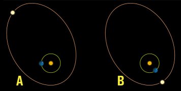
Example of "great seasons" in a binary system. The world orbits a smaller main sequence star, while a larger brighter companion is in an elliptical orbit many times longer than the planetary year. In A the other star is at almost furthest separation, and aside from the bright nights the effect on the world is not big. In B , closest separation, the star would have a much larger influence on local climate, and one of the suns would be up almost constantly. For the axial tilt-based seasons, the simplest way is to recalculate the "effective" latitude and then modify it. Lets assume that we are at 40 degrees latitude on a world with 20 degrees axial tilt. Thus, in the summer (when the sun is higher in the sky) the effective latitude is 40-20 = 20 degrees, while in the winter the latitude is 40+20 degrees = 60 degrees. Use the same moderation modifier as before for basic latitude temperature. Then, calculate the temperature difference for summer (by taking summer temperature-average temperature) and winter (by taking winter temperature-average temperature). These differences should be modified further depending on location and specifics of the world.
The rough summer and winter averages actually occur for a longer consequent time than the "averages", the equinoxes. It is easy to understand if one thinks how the "effective" latitude is at turning points at both summer and winter solstices. For calculating average temperatures on a location at a specific point, you have to extrapolate. If you will detail the world very thoroughly, it may be useful to create a basic temperature matrix like this one: |
|
For worlds with truly dense atmospheres, axial tilt will not matter. The surface will keep the same temperature regardless of season. The third calculation is the effect of day length. This is not really affected by seasons and axial tilt except in one specific case: large axial tilt that would cause extended sunlight periods at high latitudes. As the extended sunlight falls in at high angles, the heating is not that effective unless the axial tilt is very large. Otherwise, temperatures go up during the day and fall during the night. Worlds with very dense atmospheres ignore the effects of day and night temperatures just as they ignore latitude and axial tilt. |
|
The table gives the typical maximum day temperature and the typical minimum night temperature, as a modification factor to apply to the normal temperature for the region (in Kelvin). Obviously, the longer the day is the warmer it will become and the colder the nights will be. The hourly modification is calculated by seeing how many hours above the minimum for a particular column a world's day is, not the total hour length.
Just as for latitude, it is certainly possible to interpolate moderation (Average-High, etc). There will also probably be regional differences ... inland areas on a world with few clouds and low moisture will have greater day/night temperature differences than cloudy, moist coasts. It should be noted that maximum temperature isn't necessarily at noon, but slightly later as the moderation of the world delays the heating somewhat. For Earth, we are talking a delay of one or two hours. Worlds with denser atmospheres would have more delay ... in extreme cases at nightfall. The minimum temperature is just before dawn, not at midnight. MOISTURE: The presence of humidity in an atmosphere is very important for climate, and thus for landscape, ecology and landforms. It is also very important for weather, as high moisture content creates a more variable weather due to cloud formation, precipitation etc. When the air cools off, by moving over a cooler surface, for instance, or by being forced upward at a mountain range, or just by nightfall, the moisture will fall out as rain or snow. The warmer it is the more moisture will also evaporate from the surface. While I with moisture primarily mean water vapor, it can certainly be any cloud-forming component ... like methane on cooler worlds. Moisture will not always be spread equally over a world's surface, but it will be moved by weather systems so it can fall as precipitation. More about that in SIX/3. For now, we need to remember that the moisture on Earth-like worlds is dependant upon evaporation from the land, from plants, from ice caps and in particular, from oceans. How it is transported after evaporating decides how the climate zones will look. Mountain ranges often create "rainshadows", drier areas, as the moisture content drops when the air passes a mountain range and much fall as precipitation. The height and orientation of such mountain ranges decide just how dry the interior gets. POLAR CAPS: Many non-hothouse worlds will have polar caps of some kind. The low solar infall at the poles makes them significantly colder and often cool enough to have frozen water, ammonia, carbon dioxide or similar compounds. The exact composition of polar caps depend on the general coolness of the world. Very cold worlds could have methane or nitrogen-ice caps-Polar caps can be permanent (they exist year-round) or seasonal (they only exist in the cooler seasons). Seasonal polar caps are decimeters or meters thick only and highly depending on moisture. Worlds with low axial tilt has potential for bigger polar caps than worlds with average tilt, and oceans at the poles tend to diminish the size of polar caps (as the water moderates the temperatures), while land at the poles tend to provide for bigger polar ice caps. Note that a warm Earth-like world may not have any polar caps at all, temperatures at the poles must fall significantly below 273K (0 degrees C) for an extended time to create polar caps based upon ice and the summers cannot be warm enough to melt the ice in entirety. Polar caps of all kinds lower temperatures (due to the lower albedo and the cooling effect). This is most notable close to the ice caps. GEOTHERMAL HEAT: On some worlds the climate may be affect by not only solar infall but also heat from the surface due to volcanism. The biggest global heating effect on volcanism is to provide more greenhouse gasses (which warm the atmosphere) and/or more dust (which cools the atmosphere). On a regional and local level, however, the heat released can affect climate and warm areas to higher temperatures than they should have. This can have distinct effect on local cloud cover and precipitation patterns. On very young worlds, where the surface has not yet cooled off, difference in cooling in various regions will be profoundly affecting climate. CLIMATE ZONES: For further development of a world's surface, it is necessary to evaluate the climate zones of a world. There are several systems of climate zones ... the K�ppen system is perhaps the most well known, which divides Earth climate into five basic types and those in turn into several subgroups. It is often used for vegetation, but as we here will use climate for geomorphology we will use another simpler system of nine basic zones. These zones are based upon Earth-climate with moisture based upon water vapor, but will often be applicable to other worlds too. A further discussion of geomorphology for the zones is in chapter SEVEN, and of vegetation in chapter EIGHT/3. The amount of precipitation in an area depends as already have mentioned on presence to oceans, geographical location, wind patterns and how much humidity the atmosphere holds. |
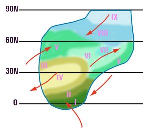
| TYPE | DESCRIPTION | Mean Annual Temperature (K) |
Mean Annual Precipitation (mm) |
| I: Hot Humid | This is the zone dominated by rain-forests on Earth | >293 | >1500 |
| II: Hot Wet-Dry | This is savanna-monsoon climate. | >293 | 600-1500 |
| III: Warm Semi-Arid | This is half-desert and warm Mediterranean climate | >293 | 300-600 |
| IV: Warm Arid | This is desert climate, Sahara-style | >293 | <300 |
| V: Moderate Humid | This is Earth's temperate climate, dominated by forests | 273-293 | >400 |
| VI: Moderate Dry | This is grasslands and steppes | 273-293 | 100-400 |
| VII: Cold Arid | This is cold desert | <293 | <100 |
| VIII: Periglacial | This is tundra-like climate | <273 | >100 |
| IX: Glacial | This is icecap climate | <273 | Varies |
Mountain climate depends upon their elevation (as temperatures drop with altitude) and location, and how dense the atmosphere is Airless worlds do not have much of climate zones (the effect on geomorphology and vegetation is certainly not mattering much), though they could be classed as glacial, cold arid or warm arid. A MODEL CONTINENT: The picture below shows an idealized and simplified continent on a world with a similar weather/ocean pattern and temperature as Earth. Using the dominant weather patterns, continent shapes (see NINE/2) and the temperatures this can be done for worlds in general.
GAS GIANT CLIMATE Unlike terrestrial planets, gas giants do not really have the same kind of climate, more of "weather" with large-scale convection. Nevertheless, weather patterns on gas giants are rather stable as there is no friction with the surface to slow them down, though the "bands" may move with time. Gas giants with strong convection (interior heat) have more violent weather, including large cyclones and anticyclones. Lighter regions on gas giants are usually those where air rises to form high clouds of ices, while the darker regions are those where air subsides and one can see down to lower clouds. The dense atmospheres of gas giants are very good at absorbing and moderating heat. Thus, seasons play a much less significant role except perhaps in the uppermost regions of the atmosphere, and so does latitude and day length. Then, gas giants tend to rotate very quickly and this creates the typical banded pattern or winds in east-west direction and gas rising from the interior in some areas and sinking in others. The jet streams of gas giants can reach supersonic speeds, and the weather systems can certainly be far more violent than on almost all terrestrial planets, with immense storms and electrical discharges. The closest analogy to "climate zones" of gas giants are directly attributed to depth into the atmosphere ... in other words the structure, pressure, moisture and heat. In some altitudes, gas giants may seem almost tolerable with water vapor and average temperatures and a more tranquil general environment. The lack of a true surface still leads to longer-lasting weather effects. Gas giants without a significant interior heat source will have far less convection and far less features. |